Prologue
Jackie Cooper planned this run for the
O.C.C. to get out and see the fall foliage. The word was passed through the message
board and a long list of attendees was assembled. Ultimately there were over 20 vehicles
and probably three times that many people who showed up. The weather was perfect
(clear, sunny, and cool).
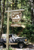
Muster
 |
|
Jeff Eppolite Photo |
The group met
at Wendy's in Manassas off route 66 at exit 47B, at about 8:30. We hit the road
about 9:00pm and arrived at the beginning of the trail about an hour or so later.
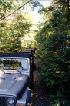
Trail


 |
|
Jeff Eppolite Photo |
10:00 a.m.
Once we drove down Route 29 to Route 230,
it was just a short hop to State Road number 657. A little ways up that, a small
group of people had assembled to wait for us. This was the actual transition to dirt
that everyone had been waiting for. At first it looked very tame, with nothing but
regular, well-graded dirt and sand.
A local yellow Labrador Retriever made
his way around, eventually reaching Teddy and Tomi. I may have done my kids a
dis-service, I am not sure. I have been regularly telling them that they should not
attempt to touch "dogs they don't know" and that they should first ask the
owner. As we are not accustomed to encountering loose dogs, Tomi was overcome with
fear when this sweet, gregarious dog just came right up and said "Howdy-do"
right in his face. The Go-Gurt went flying, the screams flew, and Mom came running.
Not a great way to start the day.
Both Ted and Tom wanted their respective
seats in the Jeep "NOW". While all this was going on, I was looking for my
air-gauge. I didn't find it and rode the trail without airing-down. Not a big
deal really, but there were lots of places where the ride was more rough than need be
because of it.
Once all the drama and acceptance of
things lost had been played out, we started up the trail with assurances from Jackie that
4-LO was not needed, but lets use it anyway to keep the speed down. She was, of
course, correct - I might even hazard to say that one could conceivably make it through
the whole day without 4WD, but there were lots of times where it was very reassuring.

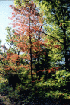
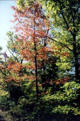
There were only a handful of trees that
had changed color and some good-natured ribbing was dispensed about the promise of
"foliage". The trail was dry and only scattered mud-showers were
encountered. The balance of the trail ride was dusty, more so once we reached
Rapidan later on.

I might be thought a wuss (what's new?)
but I will tell you that despite the easy trail surface, there were spots where it was
pretty treacherous nonetheless. The erosion is not as well controlled as the GWNF
trails; the width of the trail is quite narrow in many places, most notably in a couple
places were there are sheer drops off the side. One momentary lapse of attention or
a gas-pedal slip and things could get interesting (for the scrap man anyway...)
12:02 p.m.
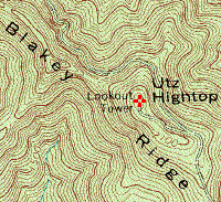
We reached
waypoint 297, one of a few side trails in this area where access to Utz Hightop may be
made.
Fortunately the trail was pretty well
rutted and the erosion was not to such a bad state that there was much chance of going off
if the driver was paying attention. We returned with everyone we left with,
and as best I could determine, there was no trail carnage, although perhaps a generous
portion of Virginia pinstriping was applied...
There are several trail branches all
along the way, many clearly posted "private property" and as many to places of
unknown status (well, I am researching my GPS track log and topo maps to gain some
insight...) and said to be "illegal". Moreover there are some trails on
the topo maps that were in evidence that might need a well placed query to confirm the
status. Suffice to say that even without taking any of the branches, its an
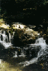
interesting ride with plenty of mild "moments" for all but the most hardened
trail riders. The biggest attraction is the view, but better stop, put it in
neutral, and crank the parking brake before taking it in.


  |
|
Jeff Eppolite Photos |
 |
|
Jackie Cooper Photo |
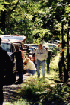
12:38 p.m.
We broke for lunch at a wide trail
junction between Blakey Ridge and Rapidan Wildlife Management Area. It was a great
spot for such a large group and everyone had a great time eating and socializing.
There were lots of cameras in evidence and plenty of film was used up, all along the
trail. The Purple Willys (Todd and crew) was a favorite subject. Look for
plenty of shots of this old-timer.

 |
|
Jeff Eppolite Photo |
After lunch,
we crossed into Rapidan Wildlife Management Area. We were in good company with all
manner of regular road vehicles. With the road surface intended for all vehicles,
the people we encountered were driving a random sampling of 2WD fare, with no great
off-road vehicle presence save our own group.

But the road was pretty
rough, with lots of erosion and rugged spots - no challenge for a Jeep, but plenty thought
provoking for anything with limited clearance. And it was choppy riding. We
wound our way up to two spots where bridges span the Rapidan. Fords are also in
evidence so naturally...


 |
 |
|
Jackie
Cooper Photos |
Most folks
took the path of least resistance through shallow water. But there were those who
needed to get a few miles out of their lift kits, "33s", "lockers",
and such, who took the road less traveled. The entertainment was not lost on the
rather large group of spectators. Lots more photos and more hang-time. The
Purple Willys and The TJ With More Stuff were the standouts here.


We terminated our exploration of new
territory at the end of the road where a gate prevents passage, and took a short
hill-climb into the woods. As the turn around was not suitable for a large group, we
each took our turns and then parked to wait for the rest to finish. With more than
20 vehicles at about 5 minutes per trip, this took considerable time.


We went down to the river with the
kids. Ted and Tom have just learned to throw rocks (great...) so I spent the time
supervising their new-found interest, lest they pummel Ron's little girls, an adult, or
someone's vehicle... That kept them busy for nearly the whole time we waited.
If you happen to stop at the same spot, you will notice that the crossing has nearly been
filled in with small stones...
4:20 p.m.
Moving back out to the spot where we ate
lunch, we stopped so people could reconnect, erect tops, and generally square away.
Then we made tracks to the pavement and Route 29, where folks started splitting off and
one core group stopped at a gas station to air-up and carry on. We said our
good-byes over the CB. It was another great day on the trail with O.C.C.!


see
waypoints
below for basic info