Prologue
After
our last brief visit to the Allegany Wildlife
Management area, Hugh decided that he'd like to go back again and do some more exploring
of the area. There was
also reported to be a trail system near Dan's Mountain, in the same
general location. This combined to give us a destination for our trip.
Muster
The O.C.C. club had their
annual holiday party on Saturday so I packed some things and stayed over at Hugh's after
the party. In the morning we headed out to Nightingale's Pond via Route 81, Route
68, and Route 36. We made a couple stops along the way for provisions, and to trade
Jeeps for a while, to compare hard-top to soft-top. We reached the trail at about
Noon-time.
Trail
Nightingale's Pond / Dan's Mountain
With all the boasting I have done about
my new J.K.S. "Quicker" disconnects, I was surprised to find that they were
somewhat difficult to disconnect. The advice that everyone gave me was "keep
them greased" made sense but after two weeks since the last time I greased them, and
a high pressure wash in between, I discovered that the sockets were very dry and not so
willing to disconnect as they had been when first installed. Note to self:
Grease them at LEAST once a week. Hugh still spent more time disconnecting but he
caught up and we finished airing down at about the same time.

The trail starts just past the end of a
driveway so if you go out there be sure not to block the driveway or the trail when you
stop to do your trail prep. Once we were ready to go we started up the trail.
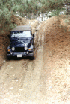
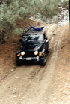
It's not very difficult - just a bumpy dirt road for most of the way. Off to the
left side there are a number of other roads that lead into private property, probably best
left unexplored.
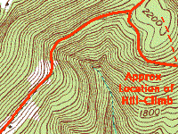
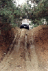
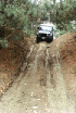
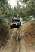
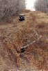
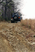
Soon we came to a steep hill
climb to the left of the road, shortly before it comes to a "T". We
stopped and walked to the top. It is pretty steep and because of recent rain, a
little slippery.
 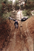
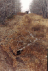
I changed from my street shoes to my
hiking boots and it was still a little difficult to get to the top on foot. Near the
top, it is heavily rutted. At the top is a trace of an old road that once ran
parallel to the current trail, but it is grown up and would be hard to get through.
So we walked back down and I volunteered
to make the first attempt. I decided to see if I could crawl up. I got about
halfway before I lost traction and slid back down while keeping my wheels slowly spinning
forward. I put it into 2nd (4-LO off course) and stormed the hill. I tried to
get just the right amount of speed so that I would reach the top of the hill moving well
but not so slow or fast that I would encounter problems. I judged it pretty well and
had no trouble getting up the ruts and onto the top of the hill. It's been a long
time since I climbed a hill this way, and got quite a rush from it.
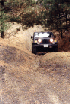
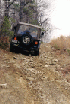
Next Hugh made a run at it. The
first time he went, he undershot the speed needed and ended up about one car length short
of the top. This meant some very careful backing down for a second try. That
time he got it right and came blasting up and landed squarely on the top.
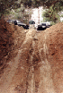
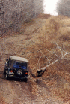
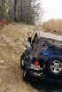
We turned the Jeeps around and took some
pictures, then spotted each other for the trip back down. I used 1st gear and found
that there wasn't enough traction, so the Jeep slid straight down the hill, outpacing the
wheels.
From here, we went down the trail to the
"T" junction. While I fumbled with camera gear and GPS waypoints, Hugh
went ahead a little and turned left into a section of mud puddles. By the time I got
there he had lined up to go through one that had tracks leading in and out.
 
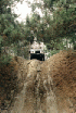
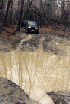
I am not really that fond of mud puddles,
so I avoid them if I can. But Hugh seems to like them, and just jumped right
in. It was a sick feeling watching as his Jeep sunk further and further. I was
waiting for it to stop going down but it kept going past the point that I would be
comfortable. All the while his ground speed is dropping and soon his wheels are
spinning and his forward motion is almost non-existent. The look on his face went
from a big smile to a look of concern. But he kept moving, even if quite slow.
 
Right near the end of the mess, he
finally got hung up on a small rock that pressed up against his front wheel, robbing what
little traction he had. With a leap of faith, Hugh took my advice to back up a
little and try again. It worked and he was able to get himself out of the
muck. We took a break to let his Jeep drain out. I opted to skip this
wonderful opportunity... We also broke out our straps and attached them to the tow
hooks in anticipation of more fun in the mud. I was not to be denied...
From here we went back to the trail and
turned left, going further up to where a long stretch of ruts and mud lay before us.
Hugh was all ready to jump in but it was so long that if he got stuck, we'd be hard
pressed to get out without using his 100 ft. cable and some hand-winching. He
actually got lined up and started to go for it but after getting crossed up in the ruts,
decided that maybe today was not the day for this obstacle.
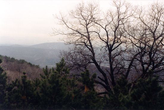
We backtracked a little ways and took a
right-hand branch that led into a nice pine grove with lots of motorcycle and ATV trails
on either side, and a nice outlook at the end. We stopped to take in the view, then
backtracked to the "T".

Past the "T", taking the right
branch, we soon came to Nightingale's Pond. There were a couple washes that had lots
of stones stacked to fix erosion. There were also several large mud puddles that
were navigable but with water that hid some large rocks.

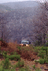
We stopped to look at the pond.
There were signs of deer near the water. The place is peaceful and no doubt could be
a nice camping area if the mosquitoes are not too thick.
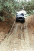
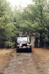
Continuing on the main trail we found a
stretch of muddy ruts and small boulders. This was not as bad as what we saw earlier
but still required careful stepping to get through without getting stuck or up against a
rock hidden by mud and water. We got past this without any problem and drove all the
way to pavement. From here we decided to turn around and go back the way we came.
We went back to Nightingale's Pond.
In an attempt to find the "berm" described in another report of this trail
system, I went down a seldom-used trail and found myself skipping my skid plates along a
high crown of the trail between the two deep, muddy ruts. Now committed I kept
moving until I reached a more solid spot a few yards ahead. Just beyond that point
was a crossing but the trail disappeared into the woods so we did 20-point turns and, with
fingers crossed, went back out through the muddy ruts.
Still trying to find the
"berm", I poked into another drier and more open trail that ran parallel to the
main trail road. But alas it just came out further up the main trail without
revealing anything new. Not content with that, we came back to the pond yet again,
and I decided to explore a meadow to the right of the pond. When I got in a few
yards I realized that there were ruts hidden by the grass and that the ruts were filled
with water. And they were deep. I pressed on deeper into the meadow and
reached the edge near the trees. I managed to stay on the high spots between the
ruts but soon realized that it was going to be tricky to turn around.
I got out and walked around, looking for
another way out that would keep me from going back the way I came in. There was
none. So I did my best to turn around, and nearly got myself back up on the high
spots. Unfortunately, I slipped off and got high centered. I could not get
moving. So a quick call to Hugh on the CB and out came the yellow strap. One
quick tug and I was back on solid ground and moving under my own power. If I had
been alone, I would have been operating my Hi-Lift jack for a couple hours...
Now that we had our fill of mud and
rocks, we traced our route back to the beginning of the trail. From there we got
back on pavement and drove towards Keyser.
Allegany Wildlife Management Area
 
I wanted to check the back entrance to
the Allegany Wildlife Management Area (AWMA). One trail report describes an
off-camber road that exits the north end to pavement. While studying maps of this
area I had found the road and its connection to pavement. I put a waypoint on my GPS
and determined to find it before we attempted to exit that way over the trail. No
sense risking an off-camber ride if there is no way out. The last thing I want to do
is be faced with turning around on the side of a hill...
So I led Hugh to the spot where my
waypoint marked the entrance. And sure enough, there is a road that comes out to
pavement. It is gated and marked private. So even though the trail may come
through (and we still don't really know that for sure) it is academic because the trail is
gated.
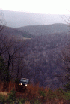
We continued along the road into
Keyser. Along the way we passed the AWMA on our right, a spectacular view. In
Keyser we stopped for a snack, then went into the AWMA using the normal route.
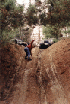
We climbed the large hill that we only
contemplated the first time we went. The main thing about this hill is the erosion
ruts - you have to avoid them as you go up the hill. I just crawled along and found
it to be pretty straightforward.
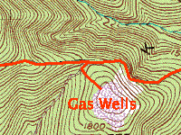
At the top, we followed a trail back
around and down to the main trail, and climbed another hill, the top of a large hill that
is exposed for the gas right of way.
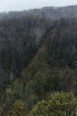
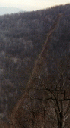
From the top of this hill, one can look
back to the south and see a long open trail that runs down into the gorge and then climbs
back up the hill on the other side. The trail appears to be frequented by ATV's.
We discussed the trail and whether or not
we'd be able to get back up to the main trail if we went down. Hugh bravely
volunteered to go down a little ways to see if he could come back up.

I guess he was figuring that he could be
retrieved using his cable, etc. if he could not come back up. But even as steep as
the hill is, he had no problem getting all the way back up, so we both followed it down
the hill.
Near the bottom, the trail leaves the
open area and ducks into the woods. It goes down a ways and reaches a creek crossing
that is wide enough for a Jeep to cross. But on the other side, the trail is only
wide enough for an ATV - unless you want to tip on about a 35-degree angle and place your
wheels on the edge of a loose, rocky mound...
We really wanted to get to the bottom of
the ravine so we could see what the trail going up the other side looks like. So we
walked down the creek bed. It is very rocky with some high drops that would bite
your bumper going down, and probably prevent us from getting back out. At the
bottom, the ATV trail meets the creek, with no easy crossing spot. A review of the
topo map shows that the trail going up the other side is probably the same gradient as the
one we came down. But with no way to get to the bottom, we have no choice but to
turn around and climb back up to the main trail.
We climbed the other hill one more time
and then decided it was time to get back to pavement, get air, gas, and food, and drive
home.


Epilogue
Along the way we stopped at the local
Jeep wash and rinsed a day's worth of muddy chunks out from under our Jeeps and only then
did we re-connect our sway bars! Gas and air and a quick visit to the drive-through
window put us on the road for home.
Back to Off Road Index
Shop for
Jeep Toys and Books | See the
Toy Jeeps
|