We drove to Keyser, WV from the
Washington, DC metropolitan area. It took us about three (3) hours not counting a
stop for dinner. Going out Route 70 (West) and thence to Route 68 (West) to
Cumberland, turning south on Route 220 to Keyser. Quite a few police cruisers out,
and most traffic strictly observing the posted speed limits. So when in Rome...
I had made reservations through
www.rebate.travelbase.com for the Keyser Econo-Lodge. I have
booked Econo-Lodges online before and it worked fine (before). I got a confirmation
number and thought I was "good to go". Wrong. When we arrived at the
Econo-Lodge, we found out that we did not have a reservation, they did not have any info
on us, and there were no rooms available. Harumph! Well things get
better. The desk clerk suggests we book in with her to the Piney Motel, just up the
street a few feet and "cheaper". Ok. let's do that - it's late and I
want to get the kids to bed. Done, off we go to the Piney Motel. It's behind
some other buildings off the road. We drive up and it's kind of creepy. We go
into the room and find a '60's style motel room, very small everything, and no air
conditioning (or heat for that matter). Alright, it's April, you'd think that you
probably don't need either. But it's about 80 degrees outside and about 100 degrees
inside. So this is not going to work on a number of levels. So back to the
Econo-Lodge. Next try, the Candlewick Inn. I drove up to town and found it
near the intersection with 220 and 46. It was open, there was a room available, it
was large, clean, and cool. Sold. I will be calling ahead in future...
After preparing for the day to come by treating our clothes with insect repellant, and
getting our youngest to go to sleep, I called it a night.
 |
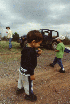
Here's the kids the next
morning ready to hit the trail with the Inn showing in the background. Tomi was
pretty miserable with a head-cold and congestion all day - you can tell by the look on his
face. |
We met up with Hugh, Mindy and Shea the
next morning near the place where we hit the trail. After gassing up we went on the trail. First we followed the road up to a knoll at the lower
gas well. This was very basic stuff - no 4WD needed.
 |
|
 |
Here's a couple shots of
the Long's Jeep as we arrived at the lower gas well. |
|
 |
|
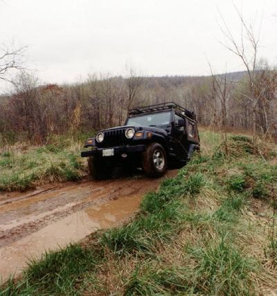
Here's a shot as the
Provencher's climb a berm |
A little further on up the trail, 4WD
becomes more appropriate. We explored the various trails, found a locked gate, and
what is probably the trail leading out to pavement. But the climb was quite steep
and we decided to leave it for another day.
 |
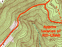
There is also a long
hill-climb that can be seen in this photo. We may or may not attempt it on a future
visit... |
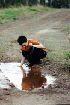
We went back to the gas wells and had lunch. The kids played with Walkie-Talkies and
in the mud puddles. We had to keep a constant eye on them so they wouldn't wander
off into the woods.
After lunch we drove back out to 220,
headed north to 46 West. Followed that around to the other side of the ridge and
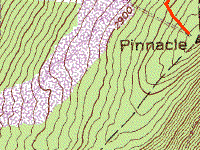
down to the entrance to the lookout tower at Pinnacle.
 |
 |
 |
These are a few views of
the lookout tower ruins and the surrounding area on Pinnacle |
Once again the trail in to the tower
didn't require 4WD for most of the road was regular dirt. A couple washouts made
having clearance and 4WD handy but someone driving a regular vehicle could have made it
through with some skill. We climbed up to Pinnacle and explored the ruins of the
lookout tower. There was a technician working on one of the radio towers.
After our nosing around we drove back
down the road a little ways and explored some side trails that eventually lead us to a
closed gate.
We contemplated our options but decided
to backtrack out the way we came. One of the side trails had a log bridge that was
down, making the crossing of a stream difficult if not impossible.
We decided not to attempt it. Most
of the travel on these side trails required 4WD and good choice of line to avoid getting
in trouble.