Prologue
10/11/01
This trip was prompted by
the discovery of a trip
report on the C.O.R.E web
site. They went out there and found some great off-road opportunities culminating in
a great view. The photos show some challenges that beckon...
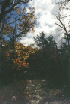
This weekend also holds the
possibility of some good foliage, so this too is an attractive incentive. The
long-range weather forecast promises a cold, rainy outlook so we anticipate the
possibility of less dust and more greasy surfaces. This will be what I hope is a
welcome change from the last several "dusty roads where they have
gone"*.
Hugh Long is signed-on for
this trip and we met along Route 15 and Route 66 Junction near Haymarket, VA in the wee
hours, then drive down to the trail.
Muster
As planned, we met about
8:15am and drove out to Route 81 on Route 66. Then we headed south on Route
81. When we got near Edinburg, I switched over to Channel 4 and shouted for
"OCC". Not too surprisingly, James C. and Roscoe P. answered. From
the message board, I knew that they were planning a run over Peter's Mill. We passed
the time of day and left the broadcast area at about the same time we had no more to
say. We continued south for about another hour until we reached our exit.
Just off the exit, we took
on fuel, last minute provisions, then headed in to Stuart's Draft. Owing to some
careless navigation on my part, we overshot one turn and took a wide loop down Route 610,
664 to the end of FR 42. There, we stopped to try and confirm our position using my
laptop and Street Atlas USA. While doing this, I noticed that I had inadvertently
backed my Jeep into a dried leaf pile and was about to ignite it from my exhaust...
How ironic that a sign at the entrance to the road warned against starting fires...
I pulled ahead and then quenched the smoldering pile.
Alas the computer gods were
not smiling on me as, for whatever reason, the PC would not see the port the GPS was
plugged in to. But based on reckoning, we correctly determined our position, and
headed up the dusty road in search of the trail.
Trail
12:25pm


We reached the trail entrance without any
more trouble. Even though the GPS seemed to be in "selective availability"
mode (lower accuracy), the coordinates I entered a few weeks ago were indispensable for
locating the trail entrance as there were many along the road, all very much the same as
each other.
We ate lunch, fed the kids, and aired
down. We talked of disconnecting but since neither of us has yet gotten quick
disconnects, we decided against it. By the time we finished the trail, we both had
resolved to put disconnects high on our "must do" lists...
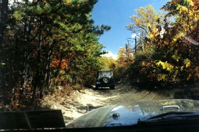
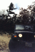
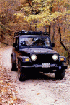
I was warned by another trail report that
there was an obstacle at the first turn in the trail. This promise was kept, and
found us pondering whether or not we'd take the bypass. After a little bit of
reasoning, mental measuring, and rock stacking, we decided to tackle it. Hugh went
first and I spotted for him. he came up to the rocks, put his tires in the position
that looked most likely and made a few tries. He kept sliding off to the side,
towards the rock, threatening to damage his body panels. But eventually he got a
good purchase on the rock and just walked over it. It took about 30 seconds. I
went next and, with the great benefit of Hugh's lessons, went right up and over it on my
first approach. Hugh was waving me off, but I chose to keep my momentum and go
up. I guess I had only 1/2 inch to spare when I got my front wheel over the rock,
and he was worried it would get worse, but I got lucky.

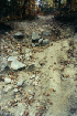
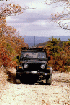
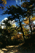
After that the rest of the trail seemed
pretty tame. But all things being relative, I will say that the trail itself is
pretty much one continuous obstacle. It appears to be an old access road that goes
straight up the mountain.
The topsoil has long ago washed away,
leaving a bed of boulders that range in size from baseball to football, to basket ball
size. Here and there are larger boulders that must be avoided, climbed, or in some
other way straddled. It all makes for some slow going, and a rough ride. But
it is satisfying to make forward motion in this terrain.
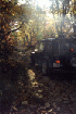
At one trail junction, there is an
obstacle just south that is one part erosion, one part rock, and a generous dose of
off-camber terrain. Hugh tried to get over it but found that his power wheels (no
lockers) both ended up off the ground.

This in combination with not
disconnecting prevented us from getting over this obstacle. It was also partly owing
to my concern that we'd either get broken, rolled, or wedged between the side and the
rock. As much help as a second vehicle can be in extricating a stuck buddy, we
didn't feel like pushing it. The trail junction included a bypass and we took
advantage of it.


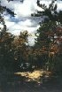
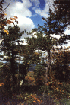
We continued on up the mountain, stopping
to enjoy the view from time to time, and to walk some of the side trails to see where they
lead. There are several trail junctions and in most cases, the path forward is the
most direct route to the top of the mountain.


The map shows that some of these trails
are just switchback options, perhaps for bad weather, that rejoin the trail further
up. We will probably explore these side-trails at some time in the future.
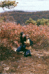
When we got to the main trail junction
and a little further along to Green Pond (which is quite small), we stopped for a break
and discovered checkerberries (wintergreen)
growing next to the trail.


Hugh was skeptical at first but trusted
me long enough to discover the subtle mint flavor of these red berries. They were
abundant. We picked several and enjoyed our snack. Be cautioned that too much
is toxic but you'll probably get tired of looking for them before you reach that limit...

From here we continued on our way the
last couple miles up the trail, which was much easier going. We encountered a couple
mountain bikers and a motorcycle rider.


Upon reaching the uppermost portion of
the trail, within a mile of the Bald Mt. Outlook, we met several vehicles coming our way,
as well as a couple walking a stroller! Near where I thought the junction with the
parkway was (I later learned that I had incorrectly marked the Lookout Tower), we found a
pair of campsites and an outhouse. My GPS track records my visit...

We doubled back on the access road a
couple times trying to resolve the incorrect waypoint, but finally got to the parkway,
where we had more snacks, made some photos and discussed our options for further
exploration.
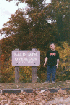
While you're out there, take
a minute to pick up the junk you find and make sure you don't leave any of your own.
Check out this note that one club likes to write in thanks to the forest
district.
Epilogue
3:30 p.m.
We decided that we had time
to go over to Shoe Creek and Crabtree
Falls and explore that trail. So we closed our log book on this trail and hit
the road for that trail system. More details
here.