Prologue
I had planned this trail
ride several weeks in advance. When Hugh and I decided to go try out
Big Levels, I realized that this trail system was so
close that it was well worth checking out at the same time, if we had enough daylight left
after we hit Big Levels. So it was that after finishing at Big Levels at about
3:30pm, we decided to hop over here and check this trail out.
Muster
3:30 p.m.
There wasn't much to
muster. We started from the Bald Mountain Overlook on the Blue Ridge Parkway, and
connected to Route 814 a little east of there, and worked our way south, down to the
northern trail entrance.
Trail
~4:00pm

The north trail head is off of Route
826 which provides access off of Route 56. This is in the vicinity of Crabtree
Falls. This series of waterfalls attracts a lot of visitors. We found both the
main entrance to the falls on Route 56 as well as the upper parking area near the
beginning of the Shoe Creek trail to be very busy. The sign at the entrance to Route
826 warns "NOTICE VEHICLES WITH A HIGH GROUND CLEARANCE OR 4- WHEEL DRIVE RECOMMENDED
BEYOND THIS POINT". The road was certainly not a problem for any of the cars we
saw traveling it. The sign probably should be placed further in near the parking
lot where the trail branches off and then becomes more of an off-road experience.


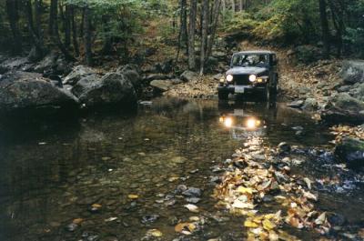
We simply ran the trail from the northern
to the southern end. All along the way we saw campsites and lots of campers.
The trail was frequently cut with erosion berms.


There were a couple of mild obstacles but
nothing that would prevent even a willing beginner from passing. Many trails
branched off the main trail. We did not have time to take them but hope to come back
and explore some more in the future.
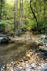
This is some of the prettiest forest I
have seen this year. The foliage was at peak, the weather was cool and dry, and
there was no wind. It was just about as nice as you could possibly hope for.
Epilogue
5:47pm


We reached the end of the
trail without event. We stopped for a minute while I attempted to connect the GPS to
my laptop. This time I wanted to save my track so that I could run the GPS on the
way out. Unfortunately the PC was still not interested in talking to my GPS so I
just packed up the PC and left the GPS off for the ride home. It turned out that my
track had been partially erased, so I am missing a few hundred feet of the beginning of
the Big Levels track, but I fortunately have just
about all of it. We hit the pavement and drove to the outskirts of Charlottesville,
where we found a KFC Buffet that fed all of us for cheap. By that time we'd had a
long day. We hit Route 29 and headed home.