Prologue
Some time ago, Hugh and I
had discussed the trail system to the north of Old Long Run, along Gauley Ridge. The
club never takes groups out into this area so we determined to go out and see what was
there. Lots of trails appear on the map but as this does not always translate to
"open" access, we knew we'd have to actually go out here and see what the real
situation held for us.
With the onset of fall, and
the end of foliage season, we finally got around to choosing this area as our
destination. In response to my suggestion that we go out, Hugh reminded me of this
area again. Although I was growing tired of Old Long Run (I think I went on this
trail three times this year), I agreed to go again, leading to this area that we had not
yet explored.
In that true small world
way, I met Carl in the parking lot at work and learned that we live in the same area and
both drive Jeeps. Carl turned me on to some
local
spots for a quick fix off off-road activity and I invited him along for some future
trip, yet to be planned. Carl dropped me a note when Hugh and I were finalizing our
plans for this ride so I invited Carl along.
Muster
I met Carl and Casie in
Gaithersburg at the Burger King. I swung through the drive-up window after getting
some cash at the ATM next-door. We spoke briefly and hit the road for
Manassas. Hugh planned to meet us at the Wendy's parking lot in Manassas, VA, at
about 8:00 a.m.

© 2001
Jeff Eppolite Photo
O.C.C. had also planned a
ride for this day and as a result, there were a couple dozen Jeeps in the parking lot when
Carl and I arrived. I went in to Wendy's so the kids could get their magic elixir
(they live to get Orange Juice here...). DOH! I was about $20 short of the
cash I had just taken out of the bank! A quick rerun of my path made me realize that
I had driven away from Burger King without getting my change... Sheesh. I
called them to see if there was any hope (hey, $20 is $20...). In fact they
remembered me and told me I could come by in the evening to get my change. I made
mental note and crossed my fingers that there would be no hassle when I got there
later. I rescued the receipt from the bag and put it in my wallet as a shred of
proof that I had been to Burger King that morning. It would prove to be a good move.
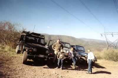
Hugh and Shea rolled in and
joined us in Wendy's for a quick bite and then our little group hit the road. But
not before Hugh and I got our "Off Camber Crawlers" club magnets! They're
huge! But they are very nice, seem to adhere well to the Jeep, and declare our
fealty for all to see...
With our colors showing, we
hit the road and drove to Harrisonburg, with a side trip to the Food Lion near Strasburg,
for a much needed pit stop. Once we reached Harrisonburg, we stopped at SubWay to
get something for lunch, and at the gas station to fuel up. The other O.C.C. group
caught up to us and were observed fueling. On our way through the town square we
caught up with the rear end of the column, and Jackie Cooper who was herding up stragglers
(Jim C.)
Even though I felt pretty
confident that I knew the turns leading to the trail entrance from Route 33 outside
Harrisonburg, I had loaded them as waypoints in the GPS. I figured that would help
me feel more confident and assure a direct hit at the trail entrance.
So I am tooling along doing
about 50 m.p.h. I can see the waypoint looming, and thinking it is still a few
hundred yards out don't give it a second thought. But in fact I had the GPS screen
set to close-up and the turn is right there- . I check my mirror, Carl
is behind but not too close. The pavement is dry and the turn not very sharp, and
there is no oncoming traffic. I ease off the gas and take the turn a bit too fast
but no great drama. I warn on the CB that I just took the turn but of course Carl
has already gone past (there was no chance he could have made it, and would have been a
fool like me for trying). Hugh hears my heads-up in time to make a more civilized
turn and Carl catches up pretty handily. We are back on track and moving toward the
trail.
Hugh opines that we are not
going the right way. It triggered my insecurity but the waypoints were right, the
landmarks looked right, and I knew that the road I took was the right one. So I
encouraged him to hang in there and see what happens. Sure enough we came to the
church without detour. I will admit though that without the waypoints and a little
map study the night before, I might have faltered.
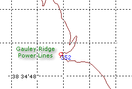
Trail
Old Long Run
We pulled onto the forest
road and then into the woods on the dirt portion of Old Long Run, right where it
starts. I pulled up far enough to let Carl and Hugh get off the main road.
Then we set about airing down, dropping top (Carl) and removing windows (Me). The
kids took this opportunity to run up and down the beginning of the trail, poke the bushes,
and do all those things kids do.
When I went to the back of
the Jeep to get started with my trail prep, I found a dead deer in a very advanced state
of decomposition. It was nothing but fur and bones, and just a remote trace of a
stench. Great. Here is a carcass within 8 inches of my back tire and I have to
let out air, etc. etc. The kids were fascinated. Great again. Now all I
need is for them to track it into the Jeep, or worse yet, start poking and prodding it
with sticks or worse... They soon got distracted by another portion of the same
carcass further up and I was able to get the rest of my stuff set to go.
Hugh chose to leave his top
up and windows installed. I wish that I had too, and I bet that Carl is probably
cursing my name as I write this. It was DUSTY! But at the time it didn't seem
like a concern. We headed out and crawled our way up Old Long Run. It was, for
the most part, dry as a bone (ha ha no pun intended). Most of the crossings were
dry, and so much easier for it. The trail is in good shape. But I find it
surprising how narrow and low it is, even with as much traffic as it gets.
Right adjacent to the
beginning of the trail is a rocky hill that folks love to climb. I climbed it the
last time I came here. I still haven't got a picture of me doing this! When we
walked down to check it out, I was considering not doing it because there was one spot
that was pretty well chewed up and looked like it might cause me to tip into the side of
the trail.
 
© 2001
Casie Smith Photos
 
While I probably would not
roll, I didn't need any new trail markings on the side of my Jeep. But Hugh was very
definitely going down, and up, so I decided that I'd watch him and go if it worked out
OK. His passage was very straightforward, so I followed like a sheep. Carl
came down as well. The return trip up was just as much fun as ever, although Tomi
was concerned that we'd tip over. This is the down side of showing your 2-year old
pictures of tipped-over Jeeps. I talked him
through it although he voiced the concern several times throughout the afternoon, with
reassurances going a long way to calm and comfort him. We don't engage
in the silliness that leads to most toppled vehicles.
    
© 2001
Casie Smith Photos
We stopped for lunch at one
of the crossings. It was very rocky with difficult footing for the kids. I sat
them down and we ate.
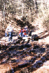
The kids were torn between
eating lunch and playing in the stream. The stream won in the end but I managed to
get them fed, have a bite myself, and also keep them from knocking out their front teeth
on the rocks. There were a couple tumbles but nothing too heinous. And after
all, they need to get their wilderness legs sooner or later...
 
While we ate, two pairs of
mountain bikers came down the trail with big smiles on their faces. I should mention
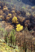
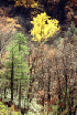
at this point that this day was cool, dry and sunny. Not a cloud in the sky.
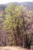
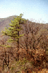
The leaves have mostly fallen but some trees are holding on. It could not have been
a better day for being in the woods.
With lunch done, we picked
up our junk and hit the trail again. I do like Old Long Run, even though it is not
very challenging. There are some spots that certainly require 4-Wheel Drive and
clearance, but not a lot of skill. Now, throw some water in the stream, some snow on
the ground, and you'd have a different story...
 
© 2001
Hugh Long Photo
   
Finally, we emerge onto
Gauley Ridge at the power line. The full beauty of the day once again is felt.
We stopped to stretch and make some photos of the surrounds, the Jeeps, and each
other. A brief discussion of options eliminated traveling up the forest road (Long
Run Road) to find the trail entrance for Dull Hunt that would lead back east to Gauley
Ridge and beyond out to Route 818. My suspicion was that Dull Hunt was probably
closed for whatever reason and we'd have spent about an hour on a smooth road with nothing
to show for it. Instead we chose to go North on Gauley Ridge Road and see which
trail junctions lead to more fun.
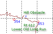
Gauley Ridge

© 2001
Casie Smith Photo

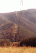
From here, the trail
descends through a series of switchbacks. There is one side trail that goes up to
the base of one power line tower.
We walked up and found a
very off-camber path that then goes back down to the regular trail. I choose
to stay on the trail but walk up to make some photos.
  
© 2001
Casie Smith Photos
We continued down to the
Junction of Slate Lick Branch. We were hoping it was a Jeep trail that would give us
some adventure. It turns out to be a hiking trail that is clearly marked to exclude
vehicles. We spend a few minutes walking around the woods and exploring the floor of
Slate Lick Branch, then saddle up again, heading back up the ridge to our next trail
junction.

© 2001
Carl
Smith Photo
Enough cannot be said about
the benefit of studying the maps in advance, and the advantage of plotting trail junctions
with a GPS. I marked several waypoints before the trip so that I could locate
potential trail junctions easily. Most of these trips, this one included, take us
into territory for the first time. With the track log turned on, it's easy to find
your way back from whence you came, but that is not enough if you are trying to locate
some place that you saw on a topo map. Anyway, I had marked out this series of trail
junctions that led west from Gauley Ridge.
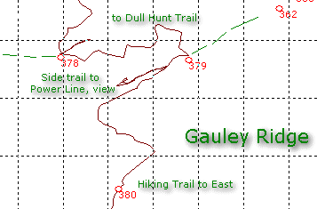

The one that ultimately
promised to lead to Dull Hunt trail appeared, indicating a left turn. A few feet
before the actual location, a left turn appeared.
So we went down to discover
a small meadow that surrounded a power line tower. End of the line. It turns
out that each power line tower that is not on the main road has an access road for
maintenance, and this was one of them.
  
Back to the main road, and a
few feet further down the road, we find our left turn and discuss our options.
 
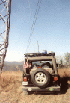
Our trail branch leads us
back down the other side of the ridge, with incredible views of the power line and the
surrounding forest. There is a strange impression left from the juxtaposition of the
geometry of the towers and the wildness of the woods. On one level it is
disappointing to have the disruption in this beautiful place but the reality is that
access here would probably be limited or non-existent without the towers, and in its own
way, the power line is impressive.

The next trail junction is
very pretty. We stopped, turned the kids loose, and scouted the various trail
entrances on foot. The trail leading West to Dull Hunt is closed with a tank trap
and lots of cut brush. This is unfortunate because the trail looks very nice and of
course, not heavily used in recent times. The trail to the East is
disappointing. It leads onto the woods with a very promising, lush setting.
Within a few yards we are met by a closed fence at the forest boundary. None shall
pass... We back-tracked out after teasingly threatening to do a "Dukes of
Hazard" stunt through the fence.
We are forced to stay on the
trail and follow it north through some beautiful country, catching some beautiful views,
and encountering a few more closed trail junctions. We encounter a few other
travelers going in the opposite direction, including a camouflage-colored mini-bus,
proving that indeed, we are not in hard-core 4-Wheel Drive territory.

Trails End
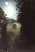
As expected, we reach Route
818 where the trail turns to gray stone, and skirts along the southern edge of the
German Mountain trail system that I
explored in July. At this point the dust was unbelievably bad. Even when I
reached pavement it took a half-mile for the dust on my Jeep to fully dissipate behind
me.
 
© 2001
Casie Smith Photos
 
A quick stop at Four Wheel
Dr. for a photo op, then we wove our way back to Rt. 259 and took our pit stop in Broadway
at the gas station. The free air for our tires was quite welcome.
Once everyone was ready we
headed back to Route 81 and headed for home. Hugh took Rt. 211, while Carl and I
backtracked on Route 66. It was a great day, with some terrific new territory behind
us. I hope to go back out again and finish qualifying the remaining trails shown on
the map.
Epilogue
On the way home I stopped by
the Burger King where I had left behind the change from my breakfast order. It was
packed with people. Darn... I took the kids in with me, asked for the manager
at the counter, and soon was met with someone with their hands full. I told him how
I had forgotten my change, had called, and was now here to get it. To my utter
surprise, he pulled from his pocket, my change, along with an exact copy of the receipt I
now had in my hand in anticipation of some sort of proof, and I was back in balance.
He gave me the money without any trouble and I was back in my Jeep (with kids) in less
than 5 minutes. I take back everything bad I ever said about Burger King. This
was a fine example of customer service in a day and age when it is very rare!
We got home by 6:30pm.
Later, it took me nearly 2 hours to get the Jeep into some semblance of order.
Between the kids aftermath (2 and 4-year olds eating in the back seat is not pretty), the
methane-smelling mud, and the dust, it was a disaster. I think the ratio of time
spent on the trail to time spent cleaning the Jeep was not very good for this trip... But
I would do it again! Thanks to Carl for coming along with Casie, and to Hugh and
Shea, for another great exploration!
Off
Road Index | Shop
for Jeep Toys and Books | See the Toy Jeeps
|