We met as usual at Wendy's
in Manassas and drove out to Broadway.
Perhaps in honor of the
holiday, there were several state police troopers enforcing the traffic laws. We
maintained the speed limit all the way to Broadway and had no problems.

We stopped for fuel and
last-minute trip instructions. Then we followed Rt. 259 to 818, and from there onto
the Forest Road.
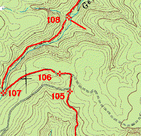


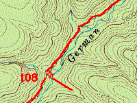
When we reached a side trail
marked "232" (waypoint 105 above) we stopped for those with full-sized vehicles
who wanted to retract mirrors and remove CB antennas. Then we started down the
trail.
The trail followed
German River down the slope.


We stopped for lunch
(waypoint 108 above) in one spot where there is a nice place to park and spread out a bit.
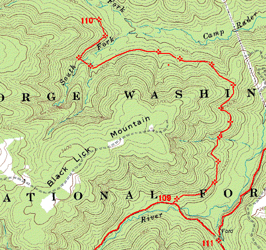

After lunch, the trail
continues along-side the river. There are some tame crossings and later, it comes to
a small ford. Just before the ford there is a side trail to the left (waypoint 109
above) that skirts the side of Black Lick Mountain.


We followed this trail to
where it is blocked with some small fallen trees, which are removed so that we can
continue. But soon enough we encounter some large fallen trees (waypoint 110
above). We back-tracked out the way we came in. This part of the map was drawn
using multiple position coordinates taken from my GPS.

Returning to the small ford,
we stop for a moment, then resume. Two of the group head out (waypoint 111 above)
and the remaining five hang a left and follow the forest road along to pavement.
By and large, the ride
consisted of terrain that could be traveled, almost without exception, by road cars with
slightly better than normal clearance, and modest driving skill. Indeed, we
encountered a Subaru Outback that was following behind us.
The trail out led us through
some territory where the property rights are in dispute. There is ample evidence of
this from the signs. We stopped at one point because it appeared that we should not
pass through one area. After some discussion, we moved ahead even though there was
some doubt. It was on improved road surfaces and many different landowners clearly
used the road to get in and out. The Subaru driver even stopped and told us that she
had been at Boy Scout camp all week and had been in and out several times without
problems.


Dinner at a country
restaurant in New Market, right next door to a "Jeep" Wash. I stopped for
gas at the other side of town and found some cute Chevron cars ("Freddy Four
Wheeler") for the kids. Another long ride home from the woods and we called it
a day!