Prologue
Jim send a note suggesting
that we take a ride on Old Long Run. I chimed in and commented that perhaps we could
tack Gauley Ridge and German River onto the itinerary. Everyone seemed to
think that was a good idea so we made plans to meet on Sunday and go out
there. Late on Saturday, I received word that some severe weather had taken
down some trees on Old Long Run, blocking the trail. So I packed a chain
saw... The weather started out cool and foggy but the weather forecast called for
"partly sunny in the high '60's, so we were optimistic.
Muster
Wendy's
I met Carl, Jeff and Chris
rolling down route 270 and continued to Wendy's in Manassas where the rest of the crowd
formed up. At about 10 minutes to 8:00, we crossed under Route 66 and had a quick
stop at McDonalds (Wendy's is marked to open at 7 but was still not open). Then we
hit the road and drove, with one stop, to McDorman's.


McDorman's
When we arrived, who should
we find, but Mark Long. I guess he decided to join us and owing to his western
starting point usually meets us out here. We lined up the Jeeps and attended to
provisions and trail prep. Most folks aired down and disconnected. My kids
went and reestablished their relationship with the dogs and large pig that are penned at
the far end of the parking lot. I don't have the heart to tell them that one day
that pig will probably be in sandwiches sold at the store... Just before we left, a
small group of various Jeeps went by, including a military surplus "something or
other".
  
We rode out to the beginning
of Old Long Run without event.
Trails
Old
Long Run | Gauley Ridge | German River
Old Long Run
Once we reached the trail
head, we found the column that went by us at McDorman's. A group of people were busy
reassembling a front hub on a Jeep and several others were checking out the military
vehicle. The rest of our group disconnected and aired down and we hit the trail.
 
The first stop was the usual
hill climb. Everyone went down and up. Wayne was making his first trip and
tackled the hill with everyone else.
    
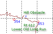
Everyone enjoyed one section
where the stream and the trail merge and a small obstacle presents itself.
    
We traveled along the trail,
stopping as necessary to check the best line, clear debris and to watch people at the
crossings. Eventually, we reached the place where a large tree and several smaller
trees had fallen across the trail.
   
Mark produced a chain saw,
and together we got started on the larger portions. The rest of the group worked
with bow saws and soon we had a path wide enough to get through without too much
trouble. It was great team work, and helped to keep the trail from taking another
diversion into the stream... From there it was an easy climb to the top of the trail
at Gauley Ridge.
Lunch
We drove up into a clearing
on the ridge and took a break for lunch. It is easy to see from the photos that the
weather was perfect: Cool, dry (trail was damp keeping dust down), sunny, and few,
if any bugs.
      

After lunch, we retraced a
previous trip route and headed down Gauley Ridge Road.
Old
Long Run | Gauley Ridge | German River
Gauley Ridge
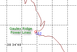
This section is a dirt road
that is easy passage. I chose it to provide an off-pavement connection to German
River, the main destination for this part of the trip. Chris, Jeff and Mark chose to
head back to civilization and presumably took FR 72 back to pavement. The rest of
the group continued (in 2WD or 4-HI) along Gauley Ridge. The views were spectacular,
and the driving was easy.
   
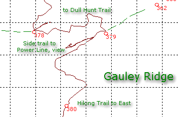
Near where the hiking trail
heads east, we encounter a large tree that had fallen across the trail. As my chain
saw was both dull and out of gas, we opted to scout and locate a bypass that allowed us to
drive around the tree. We were able to clear dead branches with a bow saw and drive
around with very low impact.
Shortly after that, I found
a flat spot and put my top down. Unfortunately, one of the few disadvantages of the
rack is the requirement that it be flipped out of the way if you are to put your top
down. This requires a level spot (or nearly so) and that the rack be empty. My
normal cargo up there is pretty light and well anchored so I usually just flip the rack
back carefully and fold the top down.
We continued to Dull Hunt
Trail and wove our way along the switchbacks. We made a brief stop to check the
view.
Eric noticed that someone in
front of him (Carl or me) had run over a green grass snake. The prognosis for
continued survival of the snake was not good. He just blended too well for his own
good, for I am sure that we would not have run over him intentionally.
Eventually, we reached
Forest Road 87. At this point it was about 3:00pm. Wayne, Ed and Elise decided
to head for pavement. We gave them general directions for getting back to pavement
and left them airing up. My apologies to them for citing "Route 813" as
one of the legs - it is actually Route 818... Later Ed told me "We made it out
without any problems. I did notice 818 and not 813, but I just kept going as the road got
better and better, and we were clearly headed for civilization."
Old
Long Run | Gauley Ridge | German River
German River
The last time I went out to
German River, we explored a piece of
trail that weaves around the side of a mountain. My hope was that this time we'd do
the same and clear the fallen timber that stopped us last time. However, since we
were running later than anticipated due to our other clearing activities, I didn't expect
we'd have time for more.
The drive up FR 87 was
longer than I remember, and rougher, but soon we reached the entrance to the trail
system. I remembered the turns from last time and my waypoints helped me feel
confident. However, at a spot between waypoints 106 and 107, a fork in the road
appeared. It looked like waypoint 107 was to be reached by going left so I chose
that fork. Wrong. We soon reached a dead end with a large hill to one
side. It appears to be decayed sandstone or something like that. I guess it's
the closest we'll come to rock crawling here on the east coast.
The approach was quite steep
and at first I didn't think it would be wise to attempt. But Jim went ahead and
started climbing it. I had walked to the top to see if there was room for a vehicle
to turn around because from the bottom it appeared that there wasn't a flat area.
There turned out to be a decent area on top so Jim's decision to climb was rewarded
when he reached the top with an easy turn-around. The first picture gives some idea
of the hill. Look at the Land Rover at the bottom and note that you are looking at
its roof...
   
Eric took his Land Rover
Discovery up a different way, but came down the same way Jim had done.
   

Next, Carl went up.
His trip up was uneventful. When he got to the top, he decided to turn around but
was still on the side of the hill. There was an awful moment where all of us
watching were yelling "STOP STOP STOP!" and "HEEEEYYYY!". Carl
was showing is the floor of his Jeep, while perched on the side of the hill... His
right-front wheel was barely touching the ground and everyone except Carl thought he was
coming down the hill using his roll-bar. He stopped this and went back up to a more
level place and turned around to come down. End of excitement.

I went up and avoided Carl's
turn around method, and came back down. I tried to use the line that "Big
Jim" had used, but my transfer case skid plate hit the break-over point, preventing
me from doing so.
            
After this little diversion,
we backtracked to the fork in the road and took the other branch. We drove down the
trail and encountered a group of horseback riders.

As soon as I saw them I
asked everyone to shut down and wait until they had passed. The riders each thanked
us, so I guess that was a good move. It is hard to know if the animals are used to
vehicles so rather than tempt fate, I just figured the best thing to do was to be silent
and still. That way the horses would not spook.
Once the riders had passed
we continued a short way to where the side trail branches of to the left. As it was
4:00 pm, I suggested that we save that for another day when the chain saw was fresh and
there was more time. I think it is about a 1.5 hour side trip not counting trail
work so it was a good decision the group made to skip it.
Shortly after crossing the
stream, we skipped the left turn that the last group had taken, and worked our way out to
FR 87 again. The trail was interesting, if not very challenging. I think I was
in 4-HI most of the way.
Trails End
 
When we got to the road, we
parked and started airing up and connecting. A local Rottweiler came out to see what
we were doing. I am glad I did not see him until after the owner came to retrieve it
as I am not very trusting of that breed of dog and might have made my kids nervous with my
concern. I know it's the training (or lack thereof) but one can never tell with any
strange dog.
It took quite a while to get
put back in road trim but we did it. I had to divide my attention between keeping
the kids out of the road and out of the creek, and to airing up, installing top, and
reconnecting. Finally we were ready to roll!
Epilogue
On the way out to the
highway, we found a little Chinese buffet. We stopped and had a bite then got back
on the road and went home.
 
We traveled all the way to
the Beltway with Carl and Eric. Jim took a south-western route so he could head out
to points west. This is a good day trip and would probably be about 2 hours shorter
with bigger compressors, chain saws, and bladders!
Off
Road Index | Shop for Jeep Toys and Books | See the Toy Jeeps
|
