Movie © 2001 Hector Aguilera
Movie © 2001 Hector Aguilera
Prologue
This trip was prompted by Carl, who thought he might like to go out again. I had to stop and think for a while, about what would be a good trip. Although Carl has not been out to Harrisonburg very much, I have done most of those trails a couple times each. So I wanted to go somewhere that was relatively new, and also challenging - I wanted to find out if my disconnects gave me any measurable benefits... Eventually, I realized that Big Levels would be a good destination for us. I announced the message on the O. C. C. message board and attracted Jim C., and Hector A. That gave us a nice group of four - All late model Wrangler TJ's. The weather was wet (for a change) during the end of the week, leaving the trails moist, not dusty - perfect for our trip.
Muster
We met at Wendy's at the usual time. Carl and I had hooked up about an hour earlier near home and drove out to Manassas. Carl got to exercise his new CB radio. Loud and clear, Carl! We stopped and got gas and soon Jim and Hector (with Zeidy and Mariela) arrived. Right before we were to leave, my kids decided they wanted breakfast (egg and cheese biscuit; pancakes) so I went to the drive-thru... And waited... And waited... I love my kids so I do these things... Finally the food came. To Tomi's credit, he ate all his pancakes without so much as a drop of syrup going awry! And Teddy polished off his egg sandwich like a champ. Thanks to the rest of the crew for being so patient with us. We hit the road at about 8:40am, headed for Stuart's Draft. The drive out Rt. 66 was uneventful, and a pit stop along Rt. 81 gave us a good stretch. Then we made a non-stop run down to Stuart's Draft and the trail head.
Trail
Big Levels
11:25am
Photo © 2001 Hector Aguilera
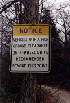
Quite the long ride. The first time I came out here I missed a road intersection and took a long loop out of the way, all the way east to the beginning of Coal Road. It was an hour wasted. This time, knowing where I went wrong, at least on paper, I paid more attention to the road and hit the turns. This brought us directly to the entrance to the Big Levels area, complete with a National Forest sign.
Photos © 2001 Hector Aguilera
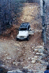
Once we hit the trail head we disconnected (me for the first time) and aired down. We also observed many crudely butchered deer carcasses. In fact there was so little gone it did not make sense why these deer were this way. A story for a different day I suppose - bear bait?? There were quite an assortment of shell casings as well as a vacuum cleaner! There are more reasons than just careless 4-wheelers to explain why trails are closed...
For anyone who has visited Big Levels, the second corner on the trail is basically your clue of what lies ahead - some moderate sized rocks placed just so. If you don't want to go over them you can take the bypass but you're just going to delay the inevitable. The rest of the trail up the mountain is nothing but rocks the size of softballs right on up to good-sized boulders. If the trail entrance puts you off, you're not going to have fun on the trail...
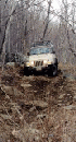
And so it was that we arrived at this spot with a few stock TJ's and Jim C.'s little-big T-Jeep-J. Hector came with his 2002 Wrangler X. 1400 and something miles on it. Now nicely pin-striped I am sure. He and the rest of us all cleared the first challenge in a total time of about 7 minutes. Then we just slapped it in low and geared straight up the side of the mountain. I was not paying close attention to Hector's camera but it turned out that not only was he making stills, he was shooting digital video!
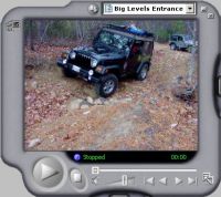
Paul - 5,245KB (Big)
Movie © 2001 Hector Aguilera
A couple days later my e-mail was crammed full with the movie and images you see on this page. Thanks Hector! These movies shows the first obstacle. I must say that you have to look closely at the movie to get the scale and perspective of this obstacle. Watch the rocker panel of the Jeep as it goes by the big rock. That rocker panel is normally a couple feet off the ground, and below that is the frame. Watch the rear wheel as it goes over the rock. Notice how it compresses almost flat against the rock as it goes over. The movie makes this obstacle look easy. Maybe it is?
Photo © 2001 Hector Aguilera
From there, the trail goes straight for quite a ways, with some nice scenery along the sides.
Photo © 2001 Hector Aguilera
When we reached a four-way junction where a large erosion puts most Jeeps in the air on opposite wheels (the power wheels spinning free), Jim made a couple swipes at it, pawing air, then took another line to the left and straddled the hole and walked right up. The photo (above) shows Jim lining up for the attempt that got him over it.
We stopped there and had lunch. Then it was more straight up the mountain over small and moderate sized rocks all the way, and a custom Virginian pin striping machine running both sides of the trail the whole time. Lots of little obstacles that make you think about line, timing, and all that. No BIG risks, no BIG challenges, just one long continuous Chinese puzzle. And the sun shone and the air was clear. The sky was incredible - I hope the photos show this.
We saw some motorcycle riders along the way. This place is also popular for mountain bikers as well.
Photos © 2001 Hector Aguilera
Along the way, we stopped here and there to look at the scenery. At one point I thought I would like to get some pine cones for my wife, who wanted them for projects for the kids. I stopped and found that they were pretty high in the trees. Carl jumped up and picked a few of them. I found that they were several years old and crumbled to dust in my hands. I don't think they will make very good project pine cones, so we left them alone and kept moving.
Photo © 2001 Hector Aguilera
Eventually we reached the plateau and started working our way around the mountain to where there were several small mud puddles. Jim and everyone else had a blast getting a new look on their Jeeps. I just kept thinking about the Jeep Wash... :-)
Photos © 2001 Hector Aguilera
We reached the Bald Mt. Outlook parking area by about 2:30, with many stops along the way to smell the scrub pines, muddy holes (well we stirred them up some before we smelled them...) and the views all along the way. Just before we reached the end of this trail we got behind a CJ5 and followed it out. I was not able to scramble my camera in time to get a photo but it was a reminder of the shorter, narrower, lower days of the pappy of the TJ.
Crabtree Falls / Shoe Creek
Big Levels | Shoe Creek
Topo Map | Shoe Creek GPS Track Legend | Way Points
C.O.R.E. Trip | Accommodations |
Last time I came out this way, we had time to run Crabtree Falls/Shoe Creek. I suggested we go there on this trip and everyone ran to the Jeep for more trail riding! From Bald Mt. Outlook, we shot south to Crabtree Falls and Shoe Creek.
First we stopped near Crabtree Meadow to take a break. This where the trail goes from dirt road to trail.
Along the way we enjoyed the rough spots and the stream crossings.
While we ran that trail, we came across the red clay hill that looks pretty formidable. Jim took a spur that went up to the top of it, but after walking it off, decided in favor of returning back to the main trail and skipping what probably would have been an interesting obstacle.
I found several sites that show pictures of people in various stages of climbing this hill, breaking and rolling equipment, etc., so I am glad Jim left it alone.
I elected an optional rock obstacle to see how my disconnected front axle would behave. Up to this point I had enjoyed a lot less body sway, better traction, and improved ease on several sections of trail that previously were more difficult. Unbeknownst to me, Hector made a photo showing me on the optional rock with my front wheel stuffed into my fender. The funny thing is, I didn't even realize it was stuffed!
Photo © 2001 Hector Aguilera
More basic trail, much less challenging than Big Levels but still really pretty this time of year, with a couple challenges to play here and there. I am probably the last to learn what everyone else knows about disconnecting - and I might be tempted to say that I wish I had bought disconnects sooner. But my procrastination paid off by giving me a chance to pick out some that really are "quicker" (off AND on). It's great to feel that front wheel drop instead of teeter-tottering, and much softer riding in general. I found the trail much easier with a whole lot less wheel slip. I know - DOH!
We stopped to look at the ruins of some sort of building. Jim took this opportunity to stuff he front wheel onto a rock. I think he knew it was stuffed!
Photos © 2001 Hector Aguilera
I kept the kids in the Jeep while we were here because I was out of energy to chase them around and prevent them from going into the rubble of this building. I didn't want them falling through the floor, picking up a rusty nail in their shoe, etc. Surprisingly, when I explained this to an exasperated Ted, he understood and actually stopped bugging me to get out! It pays to talk to your kids.
We resisted the temptation to follow several other legal and illegal trails that shoot off from the main trail, preferring instead to get back to pavement before it got too dark.
There was one side trail that goes up into the woods a little deeper. We took the hill climb and the cut-off that returns to the main trail as a little obstacle
Epilogue 4:30 p.m.
Carl led the way out and we reached the end of the trail at about 4:30pm. Since we were so far away from anything, we reconnected, aired-up, and squared away our stuff. We got moving about 45 minutes later. Jim had been playing with his new Garmin GPS and used it to look up a selection of Chinese restaurants to satisfy our need for feed. He picked one, locked in on it, and away we went. We found it first try, but ended up choosing instead to eat at the adjacent Mexican place. The Chinese place didn't have an eat-in area.
I packed enough food for an army and ate more than my share, had twice as much fun as I was entitled to, and thanks to Carl, Jim, and Hector, Zeidy and Mariela, as well as Casie, Kelsey, Ted, Tom, for making it a memorable day of riding. Now all we need to do is move this trail system about 3 hours closer to the capital area!
C.O.R.E. Trip | Len Thompson's Photos | More Big Levels Photos
C.O.R.E. Trip | Accommodations
Back to Off Road Index
Big Levels / Shoe Creek GPS Data
Update 1/5/2008: GPS Data now provided in GPX format for easy transfer to your GPS!
Purchase GPS Waypoint data and access to topographic maps of this trail using Pay Pal!
GPS Waypoint data is now available for a moderate fee ($10.00 U.S.).
This contribution allows us to maintain this web site, collect and maintain GPS waypoint data, and periodically verify its accuracy. All GPS Waypoints have been verified in the field.
If you would like to purchase the coordinates for this trail, simply complete the two questions below and click "Buy Now" to pay for your purchase using Pay Pal.
For a free sample of how our GPS data is presented to our customers, click here.
IMPORTANT - After you pay with PayPal be sure to click the orange button shown circled below from the PayPal Payment confirmation Screen to go to the GPS Data you purchased!
Photos, Layout and Design
© 2001-2008 Paul M. Provencher All Rights Reserved.
Contents of this Web Site may not be used without written permission.
Visitors Since 12/5/2001
Last Updated 02/09/2008 10:57:20 AM -0500
1383 4/6/06