Hugh Long mentioned to me
that there appear to be a number of trails in the Rawley Springs area. On various trips with the club, these
trails have not been explored. I commented that I still have not been able to go on
a trip that involves a "high place". That is to say, after a climb, I want
to be able to get out and see the surrounding area from a high elevation. The
State Line trip offered a couple opportunities
but conditions prevented me from fully enjoying them...
So I got to thinking about
different places I had heard mentioned. One that came to mind was
Flagpole Knob. Actually it was a place that I had located some
time ago on the web but for whatever reason had forgotten about. I renewed my search
and soon found a site
that describes an easy trip to the top of a high outlook. I contacted the producer
and got some additional information about location (George Washington National Forest -
GWNF) and level of difficulty (dead easy), then did some work of my own. It involved
studying the map of the greater area and developing a plan for the trip. I located
numerous trails, most probably closed (otherwise, I think I would have heard of them by
now), and a loop that provides approximately 50 miles of driving.
I organized the
GPS Way points into groups by routes and produced a line map that can be easily printed. My
GPS does not have map capability so this additional step may
not be necessary if you have something like the
Garmin e-Map and associated software (like Hugh has). I could
plug my GPS into my laptop and run my
DeLorme software but I really don't want my laptop rattling around in
my Jeep all day, just so I can see a color graphic showing me where I am...
So my plan is to go out to
Rawley Springs via Route 33, then circle the perimeter of the area and survey the various
trail entry points and identify which (if any) are open and legal. This will
eventually lead us to Flagpole Knob, and Meadow Knob, then down to Dunkle Hollow and Skidmore Dam. It is possible that owing to the distance of this
loop, we could be busy all of one day just doing the preliminary assessment. Just on
the basis of the GPS route that I put together, the loop, measured in straight lines from
one way point to another, is over 53 miles... At three miles an hour that is almost
17 hours. Since portions are on pavement, the reality is that it should only take
about 8 hours. We plan to be out there at about 8:00am.
8:30 a.m.
We drove down to the
Junction of Rt. 33 & Rt. 613, then the Junction of Rt. 613 & Rt. 742 and after a couple of zigs
and zags, the Junction of Rts. 742 & 933. Interestingly enough, the
maps I used do not have Route 933 labeled as Forest Road 225, but once we reach the end of
pavement, that is indeed what it becomes.
This approach by-passes the
perimeter route that I was planning. I originally thought this would be a dead-end
or a rough trail that we'd explore in more detail later. But it turned out to be one
of the primary entrances into the area. Once I saw that it was indeed Forest Rd 225,
we decided to go ahead and follow it as far as possible. This ended up leading us to
trails that go all the way to Flagpole Knob. Along the way we made several
observations about other trail possibilities and the scenery in general.
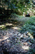
Along Route 933/FR 225 we
found the Fox Ridge Jeep Trail near the Union Springs Dam (Waypoint 210) is
closed; the Mud Pond Gap lower trail (Waypoint 221) is closed; the trail crossing opposite Upper Mud Pond Gap trail is closed.
Finding these closed was not surprising but it was disappointing. Then we found the trail gate off FR 225 (to Prospect Knob?) (Waypoint 224) closed.
This was particularly disappointing since this was a very beautiful looking area that
might have been one of the nicer scenic spots to visit on such a beautiful day. At
this point I was started to think that we'd be done running down the entrances in short
order on this branch of the route, then be back to running around the perimeter repeating
these findings over and over again.

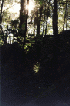
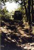
But then the road got
rougher and we turned the corner to a recognizable place. The rock face (Waypoint 225) to the west was familiar to me from pictures
others have made and placed on
web sites. Like my photos, these do not give any of idea the
scale of this hill. It is very tall and very steep. I walked to the top in the
hope that the climb led somewhere. It does not, although it is very close to the
upper Mud Point Gap trail. After a very difficult transition point into the woods,
the climb ends a few feet above. It appears quite treacherous, even if there is much
evidence that vehicles have been up into the woods. Hugh and I decided that this was
not something we "needed" to do and moved on.
We came to a fork in the
trail with an open gate that leads to the lower Black Run trail (Waypoint 192). Up to this point we had
encountered several men with pick-up trucks and hounds. When we stopped at this
junction, I spent a couple minutes talking with one of them. This is the season when
they are allowed to train their dogs in preparation for bear hunting season. So it
would appear that there are bears out here. That gives one
pause... It's time for me to
read a
refresher on how to deal with them... The gentleman was kind enough to give us
directions and some information about the trails ("they're all closed, dead ends, or
grown in") and we bid him good day.
Further in on this trail we
came to a fork and chose the road less traveled, to the left. On the map it looks
like a Pond Knob to Black Run cut-over trail (Waypoint 202). This trail
is much less well traveled and was said by the bear hunter to be a dead end with a place
to turn around.
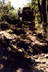
A little way in we found a
rock trough that climbed into the woods (Waypoint 226) from a trail corner. It continued (Waypoint 227) beyond a point above where Hugh and I walked
in. It looks quite challenging and even perhaps not very passable. We were not
going to try it by ourselves so we walked back out and continued west.
10:00 a.m.
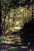
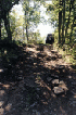
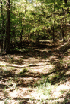
It was here that we got our
first taste of deeper woods trail riding for the day. It was something like
Old Long Run but without the stream
crossings. And somehow it seemed darker, but that may have just been my
imagination. It is a very pleasant trail that follows the side of (dry) Black Run up
into the hills. On the map, it appears to continue all the way to Pond Knob (Waypoint 203), but instead, it ends in a grassy area near
the streambed.


I didn't look closely at the
crossing so can't say if there is any chance that the trail could be navigated all the way
to Pond Knob - it was pretty grown up and the bear hunter had said that it had not been
used since the 1940's. We took a quick break and then retraced our path. On
our way out we met a couple in a pick-up truck that asked us if we were missing a
dog. All our dogs were accounted for (we started with none and still had them all)
so we said thanks and followed them back to to Forest Road 225.
There we stopped and talked
with the driver of the vehicle who had asked about the dog. He gave us directions
and trail information, warning us that he had bent two rims on the trail we planned to
take. "Kewl"! (all things being relative, I am not sure how one
could bend a rim out here on these trails but...)

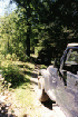
We turned north-west on FR
225 and shortly crossed the dry bed of Black Run. Just before that I noticed the
trail going about due east towards Rawley Springs. It looked open and very well
could be. We continued up FR 225 to a point below Chestnut Ridge at the top of a
mild climb where the trail has a small, dead-end spur (Waypoint 229). We caught up to the bear hunters
and stopped to talk to them again. We relayed the message about missing dogs and
they confirmed that they had been in contact with another hunter who was tracking them
with radio collars. So we continued up to where the trail was gated, presumably going up the last way to Chestnut Knob.
12:15 p.m.

As the map shows, the Jeep
trail leads off east-west and then turns north-south. It was rougher going than the
trail so far had been. The bear hunters had advised 4WD, and it was necessary (why
else would we be here?).

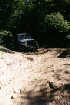
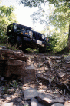
Shortly we came to a place
where the trail turned steeply downhill, and had been modified with a bypass around a
slope with a rock obstacle
(Waypoint 230). Recent signs (a partly chopped tree and tire ruts) indicated that
this could be a difficult place to get past. We were traveling west and downhill so
we chose to attempt the obstacle.
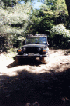
I went down without much
trouble, although I did have to choose my line carefully.
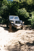
Hugh followed and acquitted
himself nicely. The bypass looks freshly cut so I imagine that this may be new trail
info for anyone who has not been out here since last year.
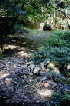
This portion of the trail is
really beautiful. It follows a high ridge line that spans the distance between
Chestnut Ridge and Meadow Knob. While it is not particularly challenging, it demands
constant attention lest a driver become distracted and get off the main trail. At
3800 feet, this is not recommended... There are no turn-around locations. I do
not believe this trail would be something to try in bad weather, or in the winter, but
everyone has different ideas about "fun"...
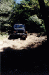
After a short section of
fairly level trail in the saddle between two higher points, we encountered a climb back
up, with some slate steps jutting out of the trail. This obstacle (Waypoint 231) is fairly typical of the challenges that these
trails provide those of us who venture out on them. I found it to be easy enough,
choosing a line that gave me choices if things got rough, and kept me from damaging my
Jeep. I crawled up in 1st-LO and didn't have any trouble keeping traction and
landing on top in one piece. The trail is narrow and steep, and the top does not
give much of a choice for where to land, so it is good that this obstacle can be
negotiated with little drama.

Hugh came next and briefly
snagged a rock with his left-front tire. He just backed off a trifle and climbed the
rest of the way without incident. We stopped to enjoy the view from here, which was
spectacular.


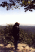
There was a another nice outlook before Meadow Knob (Waypoint 232) that we checked out too.


Next we came to a little
bypass with another optional rock obstacle (Waypoint 233), a very gratuitous one at
that. There is absolutely no reason to attempt this but we did anyway. Hugh
went first on this one (I am not much for needless challenges). I played spotter and
he took good direction. Once I saw that he got through (only with my expert
assistance :-) ), then we traded places and I took my turn.


I felt kind of goofy for
some of the photos, but what the heck...? Hugh was very diligent about making sure I
didn't mess up my Jeep. Thanks man! He also let me direct him in the making of
some photos, which involved crawling on the ground. Much appreciated as I sometimes
get almost no pictures of myself on these trips.
2:00 p.m.


Just past that we went by
the ruins of a Stone Camp (Waypoint 234), probably the namesake of this trail.
It makes me wonder why someone would go through so much trouble to build something like
that here, but it is a nice marker.


Finally we reached Meadow Knob (Waypoint 184). There was a rocky climb leading to
it that was pretty easy to manage. I realized that I had wanted to check a USGS
survey marker on the trail and headed back to see if I could find it. But the trail
passed a little way to the north of the marker and I didn't feel like traipsing through
the woods looking for it. I found a place to turn around and came back to Meadow
Knob to find Hugh visiting with Joel Lewton, Brian Langford, and Kelly Langford, who were
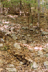
already there. We traded trail info and picked up some rubbish that was strewn
about.
3:00 p.m.
Then we loaded up and hit
the trail towards Flagpole Knob (Waypoint FLAGPL). At this point the trail opened
up and was clearly repaired by heavy equipment. After the trails we had been riding,
this seemed like super-highway. And indeed, traffic from this point forward
increased a great deal. We saw many people driving large SUV's in the direction of
the two knobs, several people camping along the sides of the roads, and most of the side
trails closed. When we reached Flagpole Knob, we found two people up there taking in
the view, and a campsite off to one side with a couple tents.


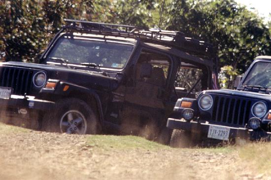
We got out and took a
break. During this time, I set up my camera and took pictures of the view, the
Jeeps, and the three of us. After a little break, we hit the road and drove back to
pavement. Along the way we found one trail opening that begged exploration, but
found many of the trails shown on the map to be closed.
While not the most difficult
'Wheeling, this was one of the nicest days, and best trail rides I have taken to
date. We shall return...