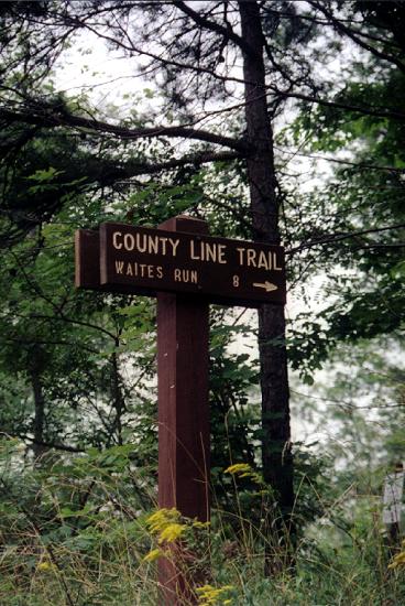
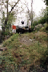
We reached the trail
without problems and prepared to go by airing down and disconnecting. This was the first
time I have aired down. I did it because I expected that I would need more traction than
usual, given the description of the trail, and also because Jackie had mentioned that
doing so also makes for a less jarring ride. I can't really say whether or not it helped
me. The ride was less harsh so in that sense it was worthwhile.
With all this done, we formed up and
headed out. The first part of the trail makes a gradual ascent. There are no drastic
off-camber sections, and only a few spots where the climb might be considered difficult
with a 2-wheel drive vehicle. 4-wheel-drive vehicles don’t often travel the trail so
it has lots of grass and weeds that are grown up, making some rocks hard to see, and
making the footing a little slippery. For most of the climb up to where the power lines
cross, it's pretty easy stuff and I didn't feel at all uncomfortable.
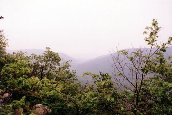
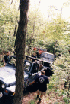
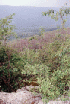
When we reached the
power lines (white dotted line to right of red
"X" on the map), the ridge drops off steeply on both sides of the trail. There
isn't much more than a foot or so on either side. Simply put, it is a
precipitous
drop if you put it wrong, and there would simply be no need for a strap...(unless you
wanted to have those who survive you sell your Jeep for salvage...). I did not mind
looking at the view on the way in. On the way out, I had tunnel vision and was very happy
to be past this point in the trail...
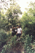
From here, things start to get more
confined and rocky. The trail is still a little obscured by grasses and weeds but the few
vehicles in front of us have at least trampled it down some, making it a little easier to
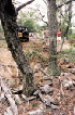
follow. Eventually, we reached the place that Jackie had referred to as the "bad
hole", a section where the trail is crowded on one side by rocks and trees, and a
sharp fall-off into a soft, off-camber section that is hard to climb out of.
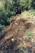
Several people make it
past here before James Hilliard reaches it and slips off into the "hole". He
spent a fair amount of time trying to get out without much luck. The pictures never show
what it looks like in person. When you see the photos you might be tempted to wonder why
anyone is getting stuck in these kinds of places. It looks so flat, and so simple. But the
pictures do not show it "like it is".
How he did it will have to
come from someone else's trail report, for I do not know where anyone could turn around
without getting badly hung up. Somehow, John managed to turn around and come back down a
soft, slightly off-camber hill to offer a winch cable to James. In the process of doing so
he intentionally tried to position his Jeep on the hill and ended up perched on the uphill
side of a tree, off the side of the trail.
At this point I decided that it was time
to scout out a turn-around spot and take my family and me out of here. I didn't yet know
that John had intentionally put himself off the trail so figured that if HE couldn't avoid
getting in a jam coming down this hill, what was I going to do later when I came back out?


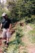
So while I was thinking it was time to
leave, and James was wallowing around, I also did some work to remove some weeds and dead
branches that visually obscured the best line for getting past "the bad hole".
When I finished this, the 'bad hole" ended up looking like a non-issue. In the
meantime, Ron, who also had expressed a desire to turn tail, had found out how John got
hung up, and had decided to go on rather than turn back. That left me the only person
wanting to leave...
I think this poses a real problem for
these kinds of trips. Understand that I don't hold it against Ron to want to continue on.
If only one person wants to leave, they are in the position of recruiting someone else who
would rather continue, parking for a while to wait for the group to return, (where there
is only one way out), or to reluctantly continue forward.

I decided that since the passage past the
"bad hole" was now very clearly do-able, and since it seemed likely that I could
keep my Jeep on the trail coming back through here, I would continue on. If I had found
someone else to "chicken out" with me, I probably would have gone back the way I
came right then. Hindsight is 20-20...
The break-over at the top of the hill was
sharp but not impossible. J.J. with a YJ went ahead of me and got his power wheels off the
ground, making his passage a little tormented, but he finally made it over. After watching
him, I was pretty sure that with a limited slip rear, I would have less trouble with that
part, so past the "bad hole" and up the hill we went.. I got over the point at
the top without any trouble, so little in fact that when I cleared it, I relaxed a little
too soon...
Just past that point, the trail veers to
the left and down slightly. I was coming down off the high point. Since the ground was
soft and very slippery (wet grass), my front end would not respond to input. We slowly
drifted off the edge of the trail and stopped without too much drama in the rocks and
trees to the side. It was so slow and so quiet that it seemed stupid. Thinking about it
now, I probably could have avoided it by using a little more gas, and by cutting the front
wheels a little harder to the left. At the time I was concerned about being off-camber and
did not want to roll over doing this. Live and learn. I also think the same limited
slip differential that helped me over the break over probably "walked" me to the
edge of the trail. A blessing and a curse in the space of 30 feet!


So out came the straps. After a few tugs
that moved me around some, I did some work thinning out the rocks and brush, and moved a
couple logs. After some jacking and another tug to move my nose to more of a 90 degree
angle to the trail, I was able climb out under my own power, without any damage. I got a
small dose of adrenaline during all this and took a couple minutes to let it abate. We
moved up the trail to let others come up the hill, and for a time it was a pleasant ride.
There were some particularly difficult
sections that got the nerves up again. But there were no disconcerting motions and the
Jeep stayed on the trail so I started to get used to being off-camber and to the high
level of readiness that this kind of driving requires.
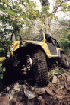
Then we encountered another rocky ascent
that led to a sharp break-over to pass over a rock outcrop and down the stepped shelf on
the other side. Mike Leitzinger in his Grand Cherokee went up the rocks nicely and paused
at the top of the break-over. His rocker panels looked to be at risk but he proceeded down
the other side without event. I went up the rock-bed and got over the outcrop without
problems, only to amble down the shelf on the other side a little too quickly (I was going
2mph, should have been going 1 mph), and again, found my nose plowing straight where the
trail went to the left.
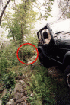
This drop-off was much more abrupt and we
just slid into a miserable hole on the right of the trail. It was also off-camber enough,
with precious little behind us to prevent further "travel" that it was initially
very disconcerting. At this point my wife and kids were not happy at all, and I was
berating myself silently for not chickening out at all costs like had originally decided.
I have still not completely stopped regretting my decision to continue.

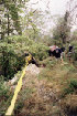

I was not the only one having problems.
Behind me, Mark Long had failed to negotiate the rocky climb to the break-over, and had
slid into an even more precarious position on the side of the rocky climb, tipped at a
good 40-degree angle. It would later be said that his might have been one of the
"best" (best meaning most difficult to recover) "stucks" ever. Even
with my own problems I was still counting my blessings that I was not in Mark's position.
The folks on either side of Mark and me
tried to retrieve us from our predicaments. It soon became apparent that Mark could not be
pulled free until my Jeep was moved out of the way of the tow vehicles used to help
Mark.


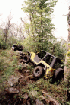
So it was that efforts were concentrated
on getting me out. Several attempts with the strap moved me around (after I released the
handbrake...) and left me wedged against rocks underneath and fallen trees to my side. At
this point, my passenger side step was mangled (but still attached), there was a little
"rounding" of the bottom of my passenger side rocker panel, and a zigzag dimple
from the tree, pressed into the side of the top rear of my body. Not thrilled was I.


When finally we "snatched" the
thing out of the hole (with wife and kids safely watching in horror), the whole passenger
side was signed with the various traces of rocks, trees and ground that met it on the way
out. The step was completely wiped off and the support bars swept back. The entire bottom
of the rocker panel was folded under, and the trailing arm mounting points were nicely
dog-eared. Later I found that my ABS braking was malfunctioning, probably from damage to
the sensors or connecting wires.
My attention went to getting my family
resituated and calmed, and to making sure that my Jeep, despite cosmetic alterations, was
fit to continue (what choice did I have?) I found the critical items to be functioning
100% so I went to watch Mark be wrenched out of his hole. He was retrieved using a snatch
block and straps, and was almost overturned on one attempt. Finally he was put back on the
trail without any visible damage. He is so calm and collected all the time it's hard to
know if his level of anxiety rose as much as mine. I know he was not happy but he did a
much better job of recovering than I.
From this point forward, I was in that
mind-zone of a person who has been told "be careful what you wish for, you might get
it". I didn't like that my Jeep was bruised. My ego can take the humiliation of it
(not that anyone taunted me) but my desire to keep my Jeep nice is another thing
altogether. Fortunately, this damage gives first-hand testimony to the need for
Sun Performance rocker protection that has been on
my "wanted" list for some
time, so in a twisted way maybe this isn't such a bad thing after all. Still it will be
some time before the budget allows for this improvement...
So I am now driving a tight, off-camber
trail that is soft and slippery. I have already gone off twice, and do not wish to do so
again. We are continuing forward at a snails pace, which is just fine by me. I know that
we are close to the end of the trail (well at least before we turn around and come back
out the way we went in...). And when we stop, I can have a snack, catch the view, try to
relax a little, and psyche myself up to make the drive out.
I opted to take advantage of a turn-out a
few yards back from the "turn-around", and am enjoying my decision to do so.
Meanwhile, Mike, Mark, Jeff, and John are all playing in the off-camber rock field below
the trails end.
We gave the kids some snacks and when
everyone was done playing, we got ready to go back out. After we had driven a few feet,
the group decided that to break into two because a few people in the back were working
through getting turned around. The weather was turning bad (rain coming down) and it was
wisely realized that it could get ugly if the weather really decided to dump on us. So
with John leading and Mike Leitzinger behind him and ahead of me, we moved on down the
"road". The off-camber section was particularly uncomfortable going back because
I was now on the low side of the Jeep where I guess it seems worse. Now I know how my wife
felt going in...
Eventually we came again to the place
that this group now calls "Paul's Hole". My wife told me that I lost all color
and did not get it back until we were several hundred yards beyond this place. The Dave
Arnette behind me very nicely provided moral and technical support to help me navigate
past the hole, keeping as far to the right as possible while allowing the whole vehicle to
slip off the hill before catching again on a rock ledge that was sticking up. Then a short
pause and climbing the off-camber, stepped rock shelf back to the high break-over point
next to "Mark's Hole", and back off-camber down the hill on the other side.
Lots of fun. Whoo Hoo. Dead silence in my
little space inside the Jeep. Then we hear John on the CB giving instructions about how to
navigate the slip of trail that goes between the dual precipices marked by the power
lines... Now this is a spot that does not allow for any error. It has been raining
for about 1/2 hour. The trail through there is slightly off-camber and covered with grass
(now wet). And I am jittery from everything behind.
When we got to that point I was thankful
for a few things. One, I can operate under pressure. I am thankful that it was foggy as
hell - in my peripheral vision I could not see a THING. And that made it easier to resist
"looking down", because I think if I did, I might have lost it completely. With
only a foot or three on either side, that would not be good... I crawled past that spot
mindful of John's advice and was greatly relieved to see trees and rocks on either side of
me once again. From here it was the kind of trail that, while not comfortable, was very
easy to navigate.

By the time we got back to the trailhead,
I was reasonably calm and collected. I was very happy to put air back into my tires (the
compressor was just as quick as a QuickAir II that someone
else had!) and after hanging around for the second group to come out, head for home.
We stopped at the Fox Den Pizza
restaurant in Strasburg, had a bite and let the kids act out some of THEIR tension, then
hit the road for home. When we neared familiar territory, who would appear ahead of us but
"Mr. Keith", coming back from his trip to Charlottesville. I raised him on
Channel 5 and we traded stories briefly before exchanging our good-byes and blending back
into the drizzle.
Things always look different after a good
night's sleep. Now that I have had the benefit of two good nights’ sleep, I still
have mixed feelings about the trip to State Line Trail. Let me say that I had a great
time. The trail was the best challenge yet. The help I got from the people while there
goes beyond what was reasonable to expect. Mike Leitzinger has marks on his Grand to
remind him of the help he gave me. My Jeep is now quite different from what it was before
it left the road on Saturday. I will eventually get the
rocker protection it obviously needs.
Update:
I got rocker protection.
I go off road to test the limit of my
capabilities and the limits of my Jeep. This pits me against the laws of physics, gravity,
and good judgement. Most of the time it is fairly easy to see the boundaries and respond
accordingly. Sometimes things happen before you have a chance to make choices.
Fortunately, in this case, nothing more than pride and sheet metal were affected. Will I
go on this trail again? Alone - NEVER. With one other vehicle? NEVER. With this group? Ask
me again when I have rocker panel protection... Update:
I ran this trail again on 2/16/02!
Ron's Photos |
Mark's
Photos | Jeff's Photos
| Eric's Photos