Prologue
I don't know how I missed
plans to spend the weekend in the
Rawley
Springs vicinity and go 'wheeling every day with camping mixed in. But I was
reading the list-serve messages and noticed that
Hugh Long had popped up there saying he was
going to be going out on Sunday to meet a small group and go for a ride. I didn't
plan to camp, even though I would have liked to, but I signed on to go for the Sunday
ride, not even knowing which trail we'd be taking.
So in the wee hours, I
stocked my provisions, outfitted the Jeep (shovel, top down, etc.) and stowed it in the
garage. I got the idea to remove my doors, so I took the two nuts off and tried
lifting the doors away. They are not that heavy but they met resistance. It
turns out that my roof rack front mounting
stays protrude too far from where they bolt to the windshield and prevent the doors from
being lifted away... They don't tell you that on the catalog pages. So
basically the Garvin Wilderness Rack makes taking the top down a 20-minute effort,
prevents the doors from being removed and the windshield from being folded down. Oh,
and you must drill holes to install it. I still love it, but was somewhat
disappointed about the doors.
I dragged myself out of bed
at 6:17 am and managed to get on the road by 7:00. That meant calling Hugh to tell
him I was running "late" but that we'd still make it to
McDorman's by 10:00am, and to look for me around
8:00am. I got to his place and we hit the road. Shea came along too.
Hugh had his doors off. We chatted along Route 66 and by the time we got to Route
81, he asked if Shea could come in with me - it was a bit nippy without the doors...
So maybe I don't feel so bad about having the doors. I had forgotten about that
part of taking them off - the wind chill factor. We stopped at the truck stop, we
gassed up, and Shea jumped in with me for the rest of the ride to McDorman's.
About 5-10 minutes above the
exit for Route 33, with Hugh and me pretty much hogging CB channel 4 (not that anyone was
trying to break in), but who should we hear but
Mark Long! It's funny how
this CB thing opens up new dimensions to our
travels. We would never have known that he was out there, in the same vicinity, had
it not been for the radio. Hugh could not hear him because of the limited range of
his handheld, but Mark told me that he would meet us at the exit. And sure enough,
there he was. We debated whether or not McDorman's would be open for business and
agreed to chance it based on our recollection that it had been open on previous Sunday
trips. We were rewarded upon arrival by finding they were indeed open.
Muster
      
 
Ken Secord, Mark Campbell,
and several others arrived on a regular basis and by 11:00am we had assembled a good crowd
of Jeeps. One person was still on the road and was checking in so we went ahead and
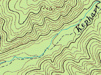
hit the trail. Mark suggested we go run
Dry River and Kephart.
This wasn't my first choice - I wasn't really that fond of a
deep ford through a river
and having done Kephart
twice, the mystery was gone. But the weather was really nice, and it didn't really
matter much where we went, so I was happy to go along. As it turned out, the trails
were both different than on previous occasions so it was a nice outing.
We hit the road down Route
33 to the Entrance to Dry River. We were to find that it really was dry this
time. There was to be no deep water crossings. I was surprised to find myself
feeling disappointed by this, a real surprise that maybe I did like that after
all... This time, we went down the
little hill and along the
river-bed that we had played on the last time out with Keith and gang, then turned right
where the trail entrance dead-ends, skipping the left turn that goes downstream a bit then
doubles back through the water
(well, the dry river bed on this trip). This trail follows the base of the ridge
that is just west, and passes by a mud hole.
The
fellow who was traveling toward us when we left McDorman's arrived. Again, the CB is
a great tool for making connections. Combined with a cell phone, you can pretty much
get together. Add a GPS and you have it all...
 

Anyway, with plenty of mud
decorating us, we continued along the trail past the dam and up the (dry) ford to the
place where the trail gets more passable.
Lunch
    
We stopped here for group
pictures and lunch. It was a great sunny spot and the line-up of Jeeps was
impressive. It took my
28mm lens
and a short walk to get far enough back to fit everyone in the shot. I also made a
shot with the fish-eye lens just for the kooky effect. While we ate and shot the
breeze, cars came and went, including the Game Warden. Shortly after he came in, a
group of trucks hustled out, followed by a two-wheel drive pick-up, testimony that some
parts of the trail were passable without 4WD. And we think we are so special! :-)
After lunch, we needed to
decide what to do next. Kephart was nominated, seconded, and without delay, the
column was moving in that direction. It seemed like minutes and indeed within two,
we were at the entrance to Kephart.
Kephart
Just as we are about to
enter the trail for Kephart, this blur of a silver Cherokee pulls up short, obviously
wanting to join us on our trail ride. As it turns out, it was Chris, Pam and Dave
Hoeltke, who had come along later and got lucky enough to find us on pavement. After
we said our howdy-do's, we crawled up the trail to Waterfall Rock, the main attraction on
this trail.

Along the way it was clear
that this trail was also a lot drier than it had been on
previous trips. But there
were a couple spots that provided some challenge, especially if it was the first time
encountered. Eventually, after much banter on the CB, we reached "the
obstacle".
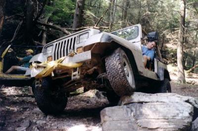
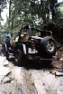
Waterfall Rock
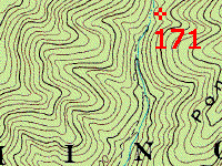
This is one of those spots
that is hard to describe. There's a rock ledge that is probably sometimes submerged
when there's water in the streambed. It is craggy and uneven. I found myself
looking at it in terms of track width, break-over angles, and turning circles. After
some study, it starts to look passable, but it still isn't easy.
The first time I came here,
I wanted no part of it, and indeed, the approach to it was not on my list of things to do
either. The second time
I came here, I was ready to try it, and ended up getting high-centered on the way back
out.
This time, the approach to
the main obstacle, a sunken streambed strew with boulders of all sizes, was rearranged
somewhat, but still recognizable. The last time I went through this I took a line
that was no longer viable - a large boulder was in the way. I was able to finesse my
way through the path that goes to the right of the tree. Another line takes you
off-camber on the left of the tree. I left that to Hugh...
 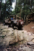  
 

  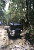  
  
Once we reached the
waterfall, everyone got out to fuss over it and then one by one, to climb it. This
time up, I took a different line since I had been fortunate
last time not to get high
centered going up, but really should not have gone the way I did.
     
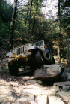
The last person to go up was
Chris Hoeltke. As soon as he made it up, he turned around, climbing every boulder he
could find, then started right back down. Not happy to just take it down easy, he
put his left-front wheel up on the large boulder that marks the gateway at the top, and
eased his rock slider and control arm down on it. Then he made some play of sliding
back and forth on the rock with his left-front wheel dangling in the breeze, finally
stuffing it and backing up over the rock again, then repeating the performance with his
rear wheel, coming in for a landing with the rear quarter a couple fractions of an inch
from the rock. I'm glad it was his Jeep and not mine!
 
A small group of people
followed the trail past Waterfall rock and found that it ends in a few hundred yards or
so. There are several possible places to continue but they all lead to really steep
climbs with no clear cut trail. A map suggests that Dictum or one of the other
trails is about a half mile from this spot, but in my mind that half mile would be
difficult if not impossible. I would like to hike it though to see what it looks
like.
After that, we all climbed
back down off the rock and made our way back to pavement. I found a disconnect pin
at one spot, testimony that someone was "auto-disconnected" there or maybe it
just fell out of a pocket. When we reached the road, the group made plans to hit
another trail. As I had to be back home by 7:30, I said my good-byes and headed out.
Epilogue
I hit the road and it felt
like the smoothest pavement I had ever driven. I drove about a mile then tried the
CB to see if anyone from our group could still hear me. I got a faint reply from
Mark Long. I wasn't too surprised because his CB is on even when he turns off his
Jeep and also he seems to get pretty good range (using the
Cobra 75 WX ST unit that I have). So I
continued on out and planned to get gas, food, and wash the Jeep at my favorite Jeep
Wash. I had just gotten to the Harrisonburg Town Square when Mark Long came on the
radio with great clarity. It followed that he must be in the same vicinity, and in
fact he and Ken were headed out together. So I stopped at the Exxon near Route 81,
started putting my top up, and shortly they arrived. I finished up my top and we hit
the car wash. I ran out of time to get food so got gas and hit the road. I
left Mark behind, probably catching a chill, and last saw Ken washing his Jeep. The
ride home was pretty good until I got back to civilization (around the 60-mile mark on
Route 66) where a four-car pile-up rendered forward progress nearly impossible.
It was a great day.
Off
Road Index | Shop for
Jeep Toys and Books | See the
Toy Jeeps
|