9:30 a.m.
We drove down to the
Junction
of Rt. 33 & Rt. 613 from Harrisonburg. After a wayward turn that doubled back to
Route 33, we got back to where I went wrong and turned right at the Junction of Rt. 613
& Rt. 742 and after a couple of zigs and zags, the Junction of Rts. 742 &
933. Route 933 turns into Forest Road 225 once we reach the end of pavement.
We drove in past the rocky
hill that some folks like to play on, and stopped to disconnect (me) and adjust shocks
(Steve). While we were out, Alec cranked up his "Grave Digger" and
"Crocodile Hunter" R/C trucks. We were all going to do some 'wheelin'
today!

The hunters with dogs were
out in great numbers, probably for bear season or something like that. I recognized
a couple of them from the time I was out here with Hugh. We followed FR 225 along
until it reaches its end near Chestnut Ridge. From there the Slate Mountain Trail
veers off sharply to the left and follows the plateau for a short distance before turning
south-west towards Meadow Knob. We stopped to take a quick break. Shortly we
came to a place where the trail turned downhill, and had been modified with a bypass
around a slope with a rock obstacle (Waypoint 230). Not a great challenge but in the
wet or with some snow it might actually merit the bypass.


A little further along the
trail climbs back up the ridge. It's a fun little hill that requires no great skill
with just a little care at the top to negotiate the holes there. I went right up and
Steve took it in 2-Wheel Drive. Like I said, not a difficult hill.


There was a another nice
outlook before Meadow Knob (Waypoint 232) that we checked out too. From there were
could see Harrisonburg in the distance, and Meadow Knob up the ridge.


Next we came to a little
bypass with another optional rock obstacle (Waypoint 233), but we left it for another day
and stayed on the main trail.

Just past that we went by
the ruins of a Stone Camp (Waypoint 234), probably the namesake of this trail (it is also
known as Stone Camp Road). Finally we reached Meadow Knob (Waypoint 184).
There was a rocky climb leading to it that was pretty easy to manage. We took a
quick peek around and moved on to the top of Flagpole Knob (Waypoint FLAGPL).
12:30 p.m.
Flagpole Knob


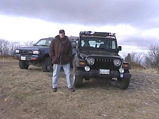
Just before we reached the
top, the road leading down to Dunkle Hollow shoots off to the right (to the left of
Steve's Navaho in the photo above). We went up to the top of Flagpole and had lunch.
It was so chilly we didn't stay outside too long. Just enough for a quick
couple of pictures, some more R/C wheeling, and then off we went, headed for Dunkle Hollow
and Skidmore Dam.


1:15
Dunkle Hollow
The trail is a recently
graded forest road that runs down from Route 33 and along the side of Skidmore Dam, then
after series of switchbacks, connects up to other trails near Flagpole Knob. We went
down from the top (I went up the first time I
traveled this trail). It is on the shaded side of the ridge so we found several
ice patches that commanded some respect. Only one or two completed covered the trail
with any size that prevented at least one tire from having a firm grip on dirt. For
these I just stuffed one side of the Jeep into the weeds on the mountain-side of the trail
and kept those tires on the dirt. It was no big deal but with the slight off-camber
grade, I can see this being a bigger challenge if the entire road became iced over.
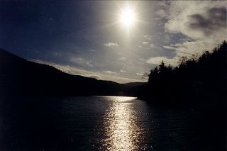
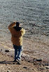
We drove down, wondering
about several side trails that branch off in various directions, some that are shown on
the map and some that are not. We took the one that leads down to the edge of the
water, where we got out for a quick break, some stone-skipping, R/C wheeling, and photos.
It turned out that there was still enough time for a little more full-sized
4-wheeling so I suggested Kephart.


So that took us out to Route
33 and down the road a bit to the entrance to Kephart.
2:15
Kephart
Not done yet you say?
I have been out here a few times (see
first time,
second trip or
third one). I skipped climbing the
rock the first time. I climbed it the second and third time. This was my first
trip with disconnects so I was looking forward to seeing what, if any difference it would
make. Steve had been out here before, and indeed, customized his rocker panels here
about as well as I did mine on State Line.
All the trails were quite
dry this time out and the trail leading to Kephart was no exception. There are a
couple spots that are more fun with water but it was just an uneventful ride out to the
obstacle that we all love to climb.


Once there we found there
was some water in the stream that runs next to the rock. It was just enough to wet
your tires just before you climbed up. Steve went first and did a nice job of going
both ways without any drama.


I went up and showed how
well a TJ flexes when disconnected and was so pleased with myself that I did a slow-speed
butt into the rock at the top that gates the trail on the right. BOOM!
Butt-head. It's the biggest rock for miles around and I hit it anyway...


Luckily I was moving really
slow and managed to center it on one of the rubber pads on my front bumper right where it
bolts to the frame. It just stopped me dead and reset the line of my back
wheels. I backed off, corrected and continued up the rest of the way without so much
as a scrape, only to exit at the top and crown my front diff cover on the only other large
boulder for miles around. CRAAACK? DOH! Again I backed off, corrected,
and got the rest of the way through. A quick check of the diff showed that all I did
was gaff up the bottom left edge of the cover - no dents, no cracks, no broken
bolts. And best of all, no bent linkage.
Worst of all, it was all
caught on video - thanks, Dave. (I have VHS tape but no way to get it on the
computer or I would share my "navigation by touch" technique with you...).
Watching the video later, my father, who sternly objects to this 4x4 activity
("If I want to go into the forest, I'm going to walk in with a pack on my back, even
if it kills me"), revelled in my clumsy driving and was quick to advise me of the
abuse I was subjecting my Jeep to. He noticed the flex but was more interested in
pointing out how someday my axle housing was going to fall off from all the stress...
We'll see... I'll grant him the need for some new bushings someday but doubt
I will have a simultaneous, total failure of all four control arms, drive shaft or
u-joints, AND track bar...
Going down the rock was
quite uneventful, and thanks to Steve's spotting, I got off the rock without any metal
touching any rocks. Dave was loving life. We drove back out to pavement, reset
our suspensions to road-mode. My disconnects worked better well greased even if I
did need Steve to push down on the bumper a bit so I could line up one side. Once we
were done with that we set a course for Metro DC...